Lidar Mapping Market Positioned to Reach $2.37 Billion by 2025: Rapid Advancements in the U.S., Germany, and South Korea
The LiDAR mapping market is reshaping how industries capture, analyze, and use geospatial data. This market’s growing importance is evident in sectors like automotive, defense, infrastructure, and environmental monitoring—fields where accuracy and real-time insights are critical.
- Last Updated:
Lidar Mapping Market Accelerates in Q1 and Q2 2025 Amid Tech Advancements
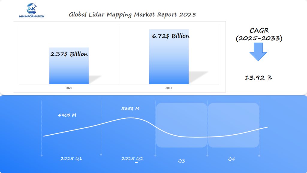
The Lidar Mapping market is on track to hit $2.37 billion in 2025, reflecting a high CAGR of 13.92% through 2033. Q1 revenue is projected at $490 million, rising to approximately $565 million in Q2. Rapid adoption across autonomous vehicles, urban planning, and environmental monitoring is pushing this growth. Lidar systems are being integrated into drones, satellites, and mobile platforms for high-resolution 3D spatial analysis.
Upstream Semiconductor Lasers and Downstream 3D Mapping and Geospatial Integration
The global LiDAR market size is projected to be valued between $2.6 billion to $2.7 billion in 2024, according to an analysis. This growth trend indicates that LiDAR technology is being increasingly adopted across various industries.
Key factors driving this valuation include:
- Technological advancements: Innovations in semiconductor lasers are enhancing the performance and reducing the costs of LiDAR systems.
- Applications in 3D mapping: Increasing demand for high-resolution geospatial data is pushing the need for advanced 3D mapping capabilities.
- Geospatial integration: The integration of LiDAR with other geospatial technologies is driving efficiency and accuracy in data collection and analysis.
The forecast suggests that the market will reach approximately $2.37 billion by 2025, with long-term projections indicating a significant rise beyond $6 billion by the late 2020s. This substantial growth highlights the importance of LiDAR technology in various sectors such as autonomous vehicles, urban planning, and environmental monitoring.
Ongoing developments in upstream semiconductor lasers are crucial for improving the range, resolution, and reliability of LiDAR sensors. These improvements enable more accurate downstream applications like real-time terrain modeling, which is vital for both commercial and defense purposes.
The strong growth of the global LiDAR market demonstrates its essential role in advancing modern geospatial solutions through innovative technology integration.
Market Trends Driven by UAV-Mounted LiDAR, Real-Time Terrain Modeling, and SLAM Tech
LiDAR has become a critical enabler for autonomous vehicles and ADAS systems, powering the next generation of automotive LiDAR applications. The integration of UAV-mounted LiDAR systems allows for rapid, high-resolution 3D mapping over large and complex environments. This capability is essential for precise environmental perception required by self-driving cars and advanced driver assistance systems.
1. UAV-Mounted LiDAR
Drones equipped with lightweight, high-precision sensors are transforming the speed and accuracy of terrain data collection. These platforms excel in hard-to-reach or hazardous areas where traditional ground-based surveys are limited, making them indispensable for highway mapping, disaster assessment, and urban infrastructure projects.
2. Real-Time Terrain Modeling
Modern LiDAR units generate millions of data points per second, enabling real-time 3D modeling of dynamic environments. Self-driving cars use this live data stream to create detailed maps that inform immediate navigation decisions—detecting obstacles, lane markings, pedestrians, and other vehicles with centimeter accuracy.
3. SLAM Technology (Simultaneous Localization and Mapping)
SLAM algorithms process incoming LiDAR data while a vehicle is in motion, allowing continuous map updates and accurate localization without reliance on GPS alone. This technology is vital for autonomous vehicles operating in urban canyons or tunnels where satellite signals are unreliable.
Automotive manufacturers leverage these advancements to increase safety levels and reliability in ADAS systems. The fusion of real-time 3D mapping with machine learning models further accelerates the adoption of autonomous mobility across global markets.
Restrictions Include Regulatory Airspace Issues, Weather Limitations, and Processing Costs
Despite the increasing use of LiDAR in various industries, there are still several obstacles that influence the direction of the Lidar Mapping Market:
1. Regulatory Airspace Challenges
UAV-mounted LiDAR systems face strict airspace regulations, especially in densely populated regions. In the U.S., FAA restrictions govern drone flight paths and operational altitudes, requiring waivers for flights beyond visual line of sight (BVLOS). These regulations limit the scalability of aerial mapping projects.
Germany enforces rigorous drone regulations to safeguard privacy and national security, impacting deployment speed for smart mobility and public infrastructure mapping.
2. Weather and Environmental Constraints
LiDAR sensors are sensitive to weather conditions. Dense fog, heavy rain, or snow can degrade data quality and accuracy. This limitation restricts year-round operations, particularly in regions with variable climates.
South Korea’s rapid automotive investment is impacted by monsoon seasons, necessitating scheduling flexibility for outdoor LiDAR surveys.
3. High Processing Costs
The vast datasets generated by high-resolution LiDAR scans demand substantial computational power for storage and analysis. Cloud-based geospatial platforms help manage this load but add recurring expenses.
For large-scale infrastructure modernization in the U.S., processing costs can be a bottleneck when integrating LiDAR into citywide projects or defense applications.

Geopolitical applications in defense, autonomous navigation, and national survey programs
LiDAR technology has become a strategic asset in the realm of defense, urban planning, and national infrastructure projects. Aerial mapping LiDAR systems deliver precise topographic data for military reconnaissance, border surveillance, and rapid-response disaster management. Defense agencies deploy airborne LiDAR to generate high-resolution digital elevation models, enabling detailed terrain analysis and mission planning in complex environments.
Defense Applications
- Aerial topographical surveys: Essential for mapping inaccessible regions.
- Environmental monitoring: Critical in detecting deforestation, erosion, or pollution events.
- Agriculture applications: Drones analyze crop health, yield estimates, and irrigation needs through high-resolution elevation models.
Autonomous Navigation
Autonomous navigation leverages LiDAR’s real-time 3D point clouds for safe traversal of unmapped or hostile territories. Armored vehicles and drones equipped with advanced sensors navigate with minimal human intervention using simultaneous localization and mapping (SLAM) algorithms powered by LiDAR data.
National Survey Programs
National survey programs increasingly rely on environmental monitoring LiDAR to track changes in land use, vegetation cover, and floodplain boundaries. Governments use these datasets for resource allocation, infrastructure upgrades, and compliance with environmental regulations.
Urban Planning Projects
Urban planning projects benefit from agriculture drones LiDAR for green space management and precision agriculture. City planners integrate LiDAR-derived geospatial layers into smart city initiatives to optimize public transport routes, monitor construction progress, and ensure resilience against natural disasters.
The breadth of geopolitical use cases continues to expand as nations prioritize precision mapping for security and sustainable development.
Type Segmentation: Aerial, Terrestrial, Mobile, and Static LiDAR Mapping
LiDAR mapping technologies are typically segmented into four main types based on deployment method: aerial, terrestrial, mobile, and static systems. Each type serves distinct operational needs and environments.
1. Aerial LiDAR
Aerial LiDAR remains the benchmark for airborne LiDAR precision in large-scale mapping technology. Mounted on fixed-wing aircraft or helicopters, these systems efficiently capture high-resolution data over vast and often inaccessible terrains. The advantages of airborne LiDAR for extensive geographic data acquisition include:
- Wide Area Coverage: Capable of surveying hundreds of square kilometers in a single flight mission.
- High Point Density: Generates dense point clouds that support detailed topographical modeling—critical for flood risk assessment, forestry management, and infrastructure planning.
- Rapid Data Collection: Ideal for projects demanding fast turnaround times such as post-disaster mapping or large government surveys.
2. Terrestrial LiDAR
Terrestrial LiDAR is deployed on tripods or platforms to scan buildings, roadways, or landscapes at ground level. This method excels in delivering millimeter-level accuracy for applications like historic preservation or construction monitoring.
3. Mobile LiDAR
Mobile LiDAR leverages vehicles or drones to collect 3D data along road corridors or rail lines. It provides a balance between coverage speed and detail, making it suitable for asset management and urban mapping.
4. Static LiDAR
Static LiDAR solutions focus on fixed installations for long-term monitoring or detailed site analysis, such as mine pit wall stability studies.
Application Segmentation: Urban Planning, Forestry, Automotive, and Mining
The Lidar Mapping Market continues to experience rapid adoption across diverse sectors driven by the adaptability and cost-effectiveness of ground-based LiDAR systems and UAV LiDAR versatility.
1. Urban Planning
City planners use LiDAR for precise 3D modeling of urban environments. High-resolution point clouds enable accurate infrastructure design, traffic management, and flood risk assessments. Planners can identify potential bottlenecks in road networks or optimize land usage with detailed elevation data.
2. Forestry
LiDAR technology is a game-changer for forest inventory, canopy analysis, and sustainable management. UAV-mounted LiDAR systems quickly map dense forests, estimating biomass, tree height, and species distribution without the need for manual fieldwork. The ability to penetrate foliage offers critical insights for conservation efforts and timber valuation.
3. Automotive
LiDAR remains essential in the evolution of Advanced Driver Assistance Systems (ADAS) and autonomous vehicles. Real-time environment mapping supports navigation, collision avoidance, and obstacle detection under varying conditions. Automotive manufacturers value LiDAR’s precision over traditional vision sensors—critical for self-driving initiatives in countries like Germany and South Korea.
4. Mining
Mining operations leverage LiDAR for volumetric surveys, safety monitoring, and site planning. Ground-based LiDAR systems capture detailed surface profiles, reducing manual labor and improving worker safety. UAV LiDAR versatility also enables rapid mapping of vast or hazardous areas with minimal downtime.
Cost reductions and modular hardware designs continue to expand the Lidar Mapping Market into new application domains where high data accuracy is crucial for efficient decision-making.
Lidar Mapping Market Scale and Adoption Across Technology-Forward Countries
Rapid advances in LiDAR technology are changing the way countries deploy mapping solutions at scale. The global push for smarter infrastructure has fueled demand for more compact, affordable, and efficient sensors, making solid-state LiDAR a key enabler for mass-market deployment.
1. Solid-State LiDAR Scalability
Unlike traditional mechanical spinning sensors, solid-state LiDAR offers fewer moving parts, leading to lower production costs and greater reliability. This shift allows manufacturers to create smaller form factors suited for integration into autonomous vehicles, drones, and mobile mapping systems. With scalable manufacturing processes, global suppliers now deliver high volumes of sensors that meet rigorous automotive and industrial use cases.
2. Cost Reductions Drive Adoption
Ongoing innovation in semiconductor laser sources, ASIC designs, and photonics packaging has significantly reduced per-unit costs. Leading manufacturers are leveraging economies of scale to supply large fleets of vehicles and UAVs with advanced 3D sensing capabilities. For example:
- U.S.: Deployment across smart city projects and defense sectors is accelerating.
- Germany: Automotive giants adopt compact LiDAR modules for next-gen mobility.
- South Korea: Mass adoption in urban monitoring and public safety initiatives relies on affordable sensor platforms.
3. Adaptable Across Industries
These technological improvements unlock new applications—ranging from precision agriculture to real-time urban analytics—making high-density 3D data accessible well beyond traditional geospatial industries.
Continuous refinement of miniaturized designs ensures that both established markets and emerging economies can access robust lidar mapping solutions without prohibitive upfront costs.
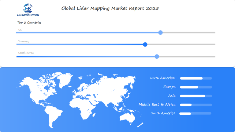
U.S. leads with smart infrastructure and autonomous lidar R&D
The United States is currently leading the way in adopting LiDAR mapping technology. This is mainly due to the country’s strong focus on developing smart infrastructure and investing in research for autonomous vehicles. Major tech companies and government-supported projects are playing a crucial role in quickly integrating LiDAR into various areas such as city planning, transportation systems, and defense applications. These initiatives are creating a situation where real-time 3D mapping becomes an essential part of managing cities instead of just an additional feature.
Challenges in LiDAR Adoption
Despite being at the forefront, there are still challenges that need to be overcome for wider adoption of LiDAR technology:
- High Initial Cost: The expensive price tag of LiDAR sensors poses a significant obstacle, especially for organizations in emerging markets or smaller municipalities.
- Technological Limitations: There are also technological barriers such as the requirement for powerful data processing capabilities and trained personnel who can understand complex geospatial outputs.
Factors Affecting Adoption
Several key factors impact the adoption of LiDAR technology:
- Budget Constraints: Municipalities often find it difficult to justify upfront capital expenditures without clear short-term return on investment (ROI).
- Data Management Complexity: Processing large amounts of data from high-resolution sensors demands substantial investment in information technology (IT) infrastructure.
- Access to Expertise: There is a shortage of skilled operators and analysts, which creates bottlenecks in deploying LiDAR solutions.
As companies in the U.S. continue to innovate, their efforts are focused on addressing these challenges by:
- Reducing sensor costs
- Developing user-friendly software platforms
- Offering scalable cloud-based analytics
These initiatives aim to make LiDAR technology accessible to a wider audience beyond just early adopters.
Germany excels in automotive lidar integration and public mapping projects
Germany stands out in the LiDAR mapping market due to its strong automotive industry and extensive public mapping initiatives. The country’s focus on integrating advanced driver assistance systems (ADAS) and autonomous driving technologies has driven substantial demand for high-precision LiDAR solutions.
Key Players:
- Hexagon AB has a significant market presence in Germany, leveraging its advanced geospatial solutions to support both automotive and public sector projects.
- Sick AG is actively forming partnerships to enhance its LiDAR offerings, focusing on industrial automation and smart city applications.
- Teledyne Technologies continues to innovate within the German market, providing cutting-edge LiDAR systems for various applications.
Applications:
- Automotive Sector: Germany’s automotive giants like BMW, Mercedes-Benz, and Volkswagen are at the forefront of incorporating LiDAR technology into their vehicles. This integration is crucial for real-time 3D mapping, object detection, and navigation.
- Public Mapping Projects: Government initiatives aimed at urban planning, infrastructure modernization, and environmental monitoring heavily rely on LiDAR data. These projects are pivotal for creating detailed topographical maps and enhancing disaster management strategies.
Advantages:
The adaptability of LiDAR technology makes it an ideal choice for diverse applications ranging from autonomous vehicles to large-scale urban planning. Its precision in capturing intricate details of geographic areas supports Germany’s emphasis on sustainability and efficient resource management.
Germany’s proactive approach in adopting and implementing LiDAR technology ensures its leadership position within the global market. This commitment to innovation in both the automotive industry and public infrastructure projects underscores the potential growth trajectory of the LiDAR mapping market.
South Korea scales adoption in smart city and drone-based surveying
South Korea stands out for its rapid integration of LiDAR mapping technologies across urban infrastructure and drone-based surveying. Government-backed smart city initiatives rely on high-resolution 3D spatial data, with LiDAR mapping underpinning the design and ongoing management of intelligent transportation systems, resilient energy grids, and public safety networks.
Key industry players are making strategic moves:
- Hexagon AB market presence extends into collaborative projects with local municipalities, enabling scalable urban modeling platforms and disaster response simulations.
- Sick AG partnerships contribute to real-time monitoring solutions for traffic management and environmental sensing. Their sensor technology powers autonomous drone fleets used in construction site monitoring, bridge inspections, and precision agriculture.
- Teledyne Technologies innovation drives the adoption of advanced airborne LiDAR for coastal zone mapping, flood risk modeling, and national land surveys.
The focus on compact, power-efficient sensors aligns with South Korea’s urban density and complex geography. Vertical integration of LiDAR data into public geospatial platforms accelerates planning cycles for both government agencies and private developers.
South Korean research centers emphasize AI-enhanced feature extraction from point cloud data, supporting predictive maintenance for infrastructure and optimizing city logistics. These advancements position the country as a regional leader in deploying LiDAR-enabled solutions at scale.
Market forecast driven by AI-lidar fusion and edge-cloud analytics
The integration of AI with LiDAR technology promises transformative advancements in the LiDAR Mapping Market. AI-driven LiDAR systems enhance real-time data processing, enabling more accurate 3D mapping and object detection. This fusion is crucial for applications in autonomous vehicles and smart infrastructure projects.
Edge-cloud analytics play a vital role in managing the large amounts of data generated by LiDAR sensors. By processing data at the edge of the network, latency is reduced, allowing for faster decision-making processes essential for applications like self-driving cars and urban planning.
Key industry players are making significant strides:
- Hexagon AB: Known for its strong market presence, Hexagon AB is investing heavily in AI-LiDAR integration to improve spatial data accuracy and processing speeds.
- Sick AG: Through strategic partnerships, Sick AG is enhancing its LiDAR offerings with advanced AI capabilities, positioning itself as a leader in industrial automation.
- Teledyne Technologies: Renowned for innovation, Teledyne Technologies is focusing on incorporating edge-cloud analytics to offer scalable and efficient LiDAR solutions.
These advancements are expected to drive substantial growth in the market. The ability to combine AI with LiDAR technology and utilize edge-cloud analytics will likely result in improved performance, lower costs, and wider adoption across various industries.
Competitive profiles in lidar hardware and geospatial software platforms
The Lidar Mapping Market is shaped by a select group of industry leaders with distinct strengths in both hardware innovation and geospatial software integration.
Key Players:
-
Velodyne LiDAR (United States)
-
Quanergy Systems (United States)
-
Luminar Technologies (United States)
-
Ouster Inc. (United States)
-
Innoviz Technologies (Israel)
-
Aeva (United States)
-
Hesai Technology (China)
-
Waymo (United States)
-
Leica Geosystems (Hexagon) (Switzerland)
-
Neuvition (China)
Overall
| Report Metric | Details |
|---|---|
| Report Name | Global Lidar Mapping Market Report |
| Base Year | 2024 |
| Segment by Type |
· Aerial LiDAR · Terrestrial LiDAR · Mobile LiDAR · Static LiDAR |
| Segment by Application |
· Urban Planning · Forestry · Automotive · Mining |
| Geographies Covered |
· North America (United States, Canada) · Europe (Germany, France, UK, Italy, Russia) · Asia-Pacific (China, Japan, South Korea, Taiwan) · Southeast Asia (India) · Latin America (Mexico, Brazil) |
| Forecast units | USD million in value |
| Report coverage | Revenue and volume forecast, company share, competitive landscape, growth factors and trends |
Global Lidar Mapping Market Report (Can Read by Free sample) – Table of Contents
Chapter 1: Lidar Mapping Market Analysis Overview
- Competitive Forces Analysis (Porter’s Five Forces)
- Strategic Growth Assessment (Ansoff Matrix)
- Industry Value Chain Insights
- Regional Trends and Key Market Drivers
- Lidar Mapping Market Segmentation Overview
Chapter 2: Competitive Landscape
- Global Lidar Mapping Players and Regional Insights
- Key Players and Market Share Analysis
- Sales Trends of Leading Companies
- Year-on-Year Performance Insights
- Competitive Strategies and Market Positioning
- Key Differentiators and Strategic Moves
Chapter 3: Lidar Mapping Market Segmentation Analysis
- Key Data and Visual Insights
- Trends, Growth Rates, and Drivers
- Segment Dynamics and Insights
- Detailed Market Analysis by Segment
Chapter 4: Regional Market Performance
- Consumer Trends by Region
- Historical Data and Growth Forecasts
- Regional Growth Factors
- Economic, Demographic, and Technological Impacts
- Challenges and Opportunities in Key Regions
- Regional Trends and Market Shifts
- Key Cities and High-Demand Areas
Chapter 5: Lidar Mapping Emerging and Untapped Markets
- Growth Potential in Secondary Regions
- Trends, Challenges, and Opportunities
Chapter 6: Product and Application Segmentation
- Product Types and Innovation Trends
- Application-Based Market Insights
Chapter 7: Lidar Mapping Consumer Insights
- Demographics and Buying Behaviors
- TargetAudience Profiles
Chapter 8: Key Findings and Recommendations
- Summary of Lidar Mapping Market Insights
- Actionable Recommendations for Stakeholders
Access the study in MULTIPLEFORMATS
Didn’t find what you’re looking for?
TALK TO OUR ANALYST TEAM
Need something within your budget?
NO WORRIES! WE GOT YOU COVERED!
Call us on: +1-866-739-3133
Email: infor@wkinformation.com
What is the current valuation and projected growth of the LiDAR mapping market by 2025?
The LiDAR mapping market is currently valued between $2.6 billion to $2.7 billion in 2024, with a projected growth to approximately $2.37 billion by 2025 and long-term projections exceeding $6 billion, driven by advancements in LiDAR technology and increasing adoption across various sectors.
How are UAV-mounted LiDAR and SLAM technology influencing market trends?
UAV-mounted LiDAR systems combined with real-time terrain modeling and Simultaneous Localization and Mapping (SLAM) technologies are driving significant market trends by enhancing autonomous vehicle navigation, enabling precise 3D mapping, and supporting applications in defense, urban planning, and environmental monitoring.
What are the main challenges restricting broader adoption of LiDAR technology?
Key restrictions limiting wider adoption of LiDAR include regulatory airspace issues affecting UAV operations, weather-related limitations impacting data collection accuracy, high processing costs associated with large datasets, and the high initial cost of advanced LiDAR sensors, especially in emerging markets.
Which countries lead in LiDAR mapping adoption and technological innovation?
The United States leads with smart infrastructure initiatives and autonomous LiDAR research and development. Germany excels in automotive LiDAR integration and public mapping projects through companies like Hexagon AB and Sick AG. South Korea is scaling adoption in smart city developments and drone-based surveying technologies.
What are the primary applications and types of LiDAR mapping technologies?
LiDAR mapping technologies are segmented into aerial, terrestrial, mobile, and static types. Applications span urban planning, forestry management, automotive systems including ADAS, mining operations, environmental monitoring, agriculture drones, and national survey programs. Airborne LiDAR offers precision for large-scale geographic data acquisition.
How is AI-LiDAR fusion shaping the future market forecast for LiDAR mapping?
AI-LiDAR fusion combined with edge-cloud analytics is driving future market growth by enabling enhanced data processing capabilities, real-time decision making for autonomous systems, improved accuracy in geospatial analysis, and scalability of solid-state LiDAR for mass-market deployment at lower costs.
RECENT REPORTS
Our clients