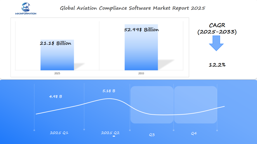
Geospatial Mapping Software Market Forecast to Reach $21.1 Billion by 2025: Expansion in the U.S., Germany, and China
Geospatial Mapping Software Market forecast to grow to $21.1 Billion by 2025, with significant expansion in the U.S., Germany, and China.
- Last Updated:
Geospatial Mapping Software Market in Q1 and Q2 of 2025
The Geospatial Mapping Software market is projected to reach $21.1 billion in 2025, with a CAGR of 12.2% from 2025 to 2033. In Q1 2025, the market size will be around $4.9 billion, growing to $5.1 billion in Q2.
Factors Driving Market Growth
The growth of this market is fueled by the increasing need for accurate location-based data across industries such as:
- Urban planning
- Transportation
- Agriculture
Key Players and Regions
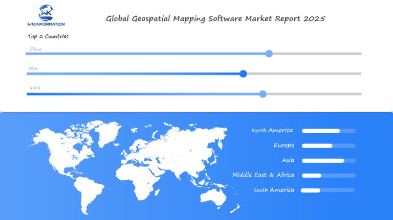
The U.S. continues to be a leader in the adoption of geospatial mapping software, particularly within government agencies and defense sectors. China’s ongoing infrastructure development also drives significant demand for geospatial mapping solutions to support smart city initiatives. Germany’s emphasis on Industry 4.0 and automation in manufacturing further propels the need for advanced mapping tools.
Emerging Opportunities
As the use of drones and satellite imagery grows, geospatial software applications are expanding into new sectors, including:
- Environmental monitoring
- Disaster management
These emerging opportunities will likely sustain strong growth for the foreseeable future.
Upstream and Downstream Supply Chain in Geospatial Mapping Software
The supply chain is essential for creating and providing geospatial mapping software solutions. It includes both upstream and downstream activities that are vital for the industry’s operation.
Supply Chain Dynamics
The supply chain in geospatial mapping software involves several key processes:
- Sourcing of raw data
- Software development
- Technology integration
- Distribution of these solutions
Efficient supply chain management ensures that all stakeholders, including data providers, software vendors, and system integrators, work together seamlessly to deliver high-quality geospatial solutions.
Upstream and Downstream Supply Chain
The supply chain can be divided into two main parts: upstream and downstream.
- The upstream supply chain involves the collection and processing of geospatial data, which serves as the foundation for developing mapping software.
- The downstream supply chain focuses on distributing and implementing geospatial mapping software through marketing, sales, and customer support efforts.
These stages are critical for ensuring the accuracy of the final product and promoting its adoption in various applications such as urban planning, disaster management, and environmental monitoring.
Key Players in the Supply Chain
Understanding the roles of key players in the supply chain is vital for navigating the complex geospatial landscape:
- Data providers such as satellite imagery companies and geographic information system (GIS) data collectors supply raw geospatial data.
- Software vendors like ESRI and Google develop mapping software using the provided data.
- System integrators implement these solutions for specific applications, ensuring that the software meets end-users’ needs.
Effective collaboration among these players is crucial for delivering innovative and effective geospatial mapping solutions.
Trends in real-time mapping, GIS integration, and spatial data analytics
The Geospatial Mapping Software Market is experiencing a significant change with the rise of real-time mapping, GIS integration, and spatial data analytics. These technologies are transforming how organizations function by offering them immediate insights and empowering decision-making based on data.
Emerging Trends
The integration of real-time mapping, GIS, and spatial data analytics is giving rise to emerging trends in the Geospatial Mapping Software Market. Real-time mapping enables organizations to track and monitor assets in real-time, while GIS integration provides a framework for analyzing and interpreting geospatial data. Spatial data analytics is becoming increasingly important for businesses to gain insights and make informed decisions.
The market is witnessing a significant shift towards the adoption of cloud-based solutions, which are more scalable and cost-effective. Additionally, the use of artificial intelligence and machine learning is becoming more prevalent in geospatial mapping software, enabling organizations to automate processes and gain deeper insights.
Impact on Business Decision-Making
The trends in real-time mapping, GIS integration, and spatial data analytics are having a significant impact on business decision-making. Organizations are using these technologies to gain insights into customer behavior, optimize operations, and identify new business opportunities.
The following table highlights the key trends and their impact on business decision-making:
| Trend | Description | Impact on Business Decision-Making |
| Real-time Mapping | Enables organizations to track and monitor assets in real-time | Improved operational efficiency and reduced costs |
| GIS Integration | Provides a framework for analyzing and interpreting geospatial data | Enhanced data analysis and insights |
| Spatial Data Analytics | Enables businesses to gain insights and make informed decisions | Data-driven decision-making and improved business outcomes |
Barriers related to data privacy, security, and high implementation costs
The adoption of geospatial mapping software is hindered by concerns about data privacy, security, and high implementation costs. As organizations increasingly depend on geospatial technology to guide their decision-making processes, they must also overcome the difficulties that come with its use.
Challenges in Data Privacy and Security
Data privacy and security are significant concerns in the geospatial mapping software market. Geospatial data can be sensitive and vulnerable to cyber threats, making it essential for organizations to implement robust security measures to protect their data. Some of the key challenges in data privacy and security include:
- Protecting sensitive information from unauthorized access
- Ensuring compliance with data protection regulations
- Mitigating the risk of data breaches and cyber attacks
To address these challenges, organizations can implement various security measures, such as encryption, access controls, and regular security audits. By prioritizing data privacy and security, organizations can build trust with their stakeholders and ensure the long-term viability of their geospatial mapping software initiatives.
High implementation costs
are another significant barrier to the adoption of geospatial mapping software. Organizations must invest in hardware, software, and training to effectively utilize geospatial solutions, which can be a significant upfront expense. To mitigate these costs, organizations can consider:
- Cloud-based solutions, which can reduce the need for upfront capital expenditures
- Phased implementation approaches, which can help to spread out the costs over time
- Partnering with experienced geospatial technology providers, which can help to reduce the costs associated with implementation and training
By adopting these strategies, organizations can reduce the financial burden associated with implementing geospatial mapping software and unlock the full potential of their geospatial data.

Geopolitical Trends in Geographic Information Sharing and Regulatory Frameworks
Geopolitical trends are reshaping the way geographic information is shared across borders, influencing global collaboration and decision-making. The increasing importance of geospatial data in various sectors has led to a complex landscape of regulations and geopolitical considerations.
Geopolitical Trends
The sharing of geographic information is critical for global initiatives, but it is hampered by varying regulatory frameworks and geopolitical tensions. Countries have different policies regarding the use and dissemination of geospatial data, affecting international collaborations.
For instance, some nations impose strict controls on the export of geospatial data, citing security concerns. This has led to a fragmented global market where organizations must navigate diverse regulatory environments to operate effectively.
Regulatory frameworks play a crucial role in shaping the geospatial mapping software market. Governments and international bodies are establishing guidelines to ensure the secure and ethical use of geospatial data.
- Data privacy laws are becoming more stringent, impacting how geospatial data is collected and shared.
- International collaborations are driving the development of standardized regulatory frameworks.
- Organizations must comply with these regulations to operate globally, necessitating flexible and adaptable geospatial solutions.
Understanding these geopolitical trends and regulatory frameworks is essential for organizations to navigate the complex landscape of the geospatial mapping software market. By staying informed and adapting to these changes, businesses can capitalize on opportunities in this evolving market.
Type segmentation: desktop-based, cloud-based, and hybrid mapping solutions
The market for geospatial mapping software can be categorized into three main types: desktop-based, cloud-based, and hybrid mapping solutions. Each type offers distinct advantages and is suited to different organizational needs.
Desktop-Based Solutions
Desktop-based solutions are known for their robust functionality and control. They are typically installed on individual computers or local servers, providing users with direct access to the software and its features without relying on internet connectivity. This characteristic makes desktop-based solutions particularly appealing for applications requiring high levels of data security and privacy.
Moreover, desktop-based GIS software often offers advanced tools for spatial analysis and data editing, making them a favorite among professionals who require precise control over their data and workflows. However, they may require significant upfront investment in hardware and software, and maintenance can be resource-intensive.
Cloud-Based Solutions
In contrast, cloud-based solutions offer scalability and flexibility, allowing users to access their data and applications from anywhere, at any time, provided they have an internet connection. This flexibility is particularly beneficial for organizations with distributed teams or those that require rapid deployment of geospatial mapping capabilities.
Cloud-based GIS software also reduces the need for upfront capital expenditures on hardware and software, as costs are typically subscription-based. However, they may be subject to internet connectivity issues and data security concerns if not properly managed.
Hybrid Mapping Solutions
Hybrid mapping solutions combine the benefits of both desktop and cloud-based solutions. They offer the control and functionality of desktop-based solutions while leveraging the scalability and accessibility of cloud-based solutions. This makes hybrid solutions highly adaptable to a wide range of organizational needs and preferences.
When choosing a geospatial mapping solution, organizations must consider their specific requirements, including data security needs, scalability requirements, and the level of control desired over their GIS applications. By understanding the characteristics of desktop-based, cloud-based, and hybrid mapping solutions, organizations can make informed decisions that best support their operational goals.
Application segmentation: urban planning, disaster management, and environmental monitoring
Geospatial technology is transforming various sectors, including urban planning, disaster management, and environmental monitoring. The versatility of geospatial mapping software allows it to be applied in diverse fields, enhancing decision-making and operational efficiency.
Urban Planning Applications
Urban planning is a critical area where geospatial mapping software is extensively used. Urban planners utilize geospatial data to optimize urban infrastructure, manage resources, and plan for future growth. Some of the key applications in urban planning include:
- Land use planning and zoning
- Transportation planning and management
- Urban development and infrastructure planning
Urban Planning with Geospatial Technology
Disaster Management and Environmental Monitoring
Disaster management and environmental monitoring are other vital applications of geospatial mapping software. In disaster management, geospatial technology is used to respond to and mitigate the impact of natural disasters. This includes:
- Disaster risk assessment and mapping
- Emergency response planning and coordination
- Damage assessment and recovery efforts
Environmental monitoring involves tracking and monitoring environmental changes, such as deforestation, climate change, and natural resource management. Geospatial technology enables the collection and analysis of data over time, providing insights into environmental trends and patterns.
The use of geospatial technology in these applications not only enhances the efficiency of operations but also improves decision-making by providing accurate and timely data. As the geospatial mapping software market continues to evolve, we can expect to see even more innovative applications in urban planning, disaster management, and environmental monitoring.
Global adoption of GIS for smart cities and sustainable development
As the world becomes more urbanized, GIS technology is being increasingly adopted for smart city initiatives. This adoption is driven by the need for efficient urban planning, resource management, and sustainable development.
The integration of GIS in urban planning enables cities to become smarter and more sustainable. It facilitates the creation of integrated infrastructure, optimizes resource allocation, and improves citizen services.
Smart Cities Initiatives
Smart cities are using GIS to create integrated infrastructure, optimize resource allocation, and improve citizen services. Here are some key areas where GIS is being applied:
- Urban Planning: GIS helps in designing and managing urban spaces more effectively.
- Transportation Management: GIS enables the optimization of traffic flow and public transportation systems.
- Public Safety: GIS is used for crime mapping and emergency response planning.
The use of GIS in smart cities aligns with several Sustainable Development Goals (SDGs), such as:
- SDG 11: Sustainable Cities and Communities – GIS helps in creating sustainable and resilient cities.
- SDG 13: Climate Action – GIS is used for climate change mitigation and adaptation strategies.
- SDG 9: Industry, Innovation, and Infrastructure – GIS supports the development of sustainable infrastructure.
By adopting GIS technology, cities can make significant progress in sustainable development and enhance the quality of life for their residents. The widespread use of GIS for smart cities globally demonstrates the effectiveness of geospatial technology in shaping the future of urban areas.
U.S. leadership in geospatial data analytics and spatial intelligence
The United States is leading the way in geospatial data analytics and spatial intelligence, thanks to technological advancements and strategic initiatives. This leadership is not accidental but the result of a concerted effort by both the government and the private sector to use geospatial data for informed decision-making.
Geospatial Data Analytics
Geospatial data analytics involves using advanced analytics techniques to extract insights from geospatial data. This field has seen significant growth in the U.S., with many organizations developing sophisticated tools and methodologies to analyze and interpret complex data sets. Key applications include urban planning, disaster management, and environmental monitoring, where accurate geospatial analysis can lead to more effective and sustainable solutions.
The U.S. is home to several pioneering companies and research institutions that are pushing the boundaries of geospatial data analytics. For instance, the integration of Artificial Intelligence (AI) and Machine Learning (ML) algorithms with geospatial data has opened up new opportunities for predictive analytics and spatial modeling.
Spatial Intelligence
Spatial intelligence refers to the ability to understand and interpret spatial data to make informed decisions. In the context of the U.S., spatial intelligence is being utilized across various sectors, including defense, urban planning, and logistics. The use of spatial intelligence enables organizations to visualize complex data in a spatial context, thereby facilitating better decision-making.
- Enhanced situational awareness through real-time data analysis
- Improved planning and resource allocation
- Better risk management through predictive analytics
The U.S. government’s initiatives, such as the National Geospatial-Intelligence Agency’s (NGA) efforts to enhance geospatial intelligence, have played a crucial role in promoting the adoption of spatial intelligence across different sectors.
In conclusion, the U.S. leadership in geospatial data analytics and spatial intelligence is a result of a combination of technological innovation, strategic government initiatives, and the presence of key players in the industry. As these fields continue to evolve, the U.S. is well-positioned to maintain its leadership role.
Germany’s Use of Geospatial Mapping in Engineering and Logistics
With its robust infrastructure, Germany is leading the way in using geospatial mapping in engineering and logistics. The country’s strong manufacturing sector has been a major factor in the widespread use of this technology.
Geospatial mapping is being used to streamline production processes, enhance supply chain efficiency, and improve infrastructure development. This technology provides accurate spatial data that is essential for various applications in Germany‘s engineering and logistics industries.
Geospatial Mapping in Engineering
In engineering, geospatial mapping is used for infrastructure development, transportation planning, and monitoring environmental changes. This technology enables precise planning and execution of projects, thereby reducing costs and improving timelines.
Applications and Benefits of Geospatial Mapping in Engineering
| Application | Benefits | Impact |
| Infrastructure Development | Precise planning, reduced costs | Improved project timelines |
| Transportation Planning | Efficient route planning | Reduced delivery times |
| Supply Chain Optimization | Real-time tracking, optimized logistics | Lower operational costs |
The integration of geospatial mapping in engineering and logistics is a testament to Germany‘s commitment to technological advancement and efficiency.
China's government-driven urbanization and smart city mapping
Government initiatives in China are propelling urbanization forward, leveraging cutting-edge geospatial technology. This strategic approach is transforming urban landscapes and setting new standards for smart city development.
Urbanization Trends
China’s urbanization is characterized by rapid growth and large-scale infrastructure projects. Geospatial technology plays a crucial role in this process, enabling efficient planning, monitoring, and management of urban development. The use of geospatial data allows for the creation of detailed maps and models that help in understanding urban dynamics and planning for future growth.
The integration of geospatial technology in urban planning has several benefits, including:
- Improved infrastructure planning
- Enhanced disaster management
- Better resource allocation
- Increased efficiency in urban services
Smart City Initiatives
China’s smart city initiatives are a key aspect of its urbanization strategy. These initiatives involve the use of advanced technologies, including geospatial mapping, to create intelligent infrastructure and improve the quality of life for citizens. Smart city solutions are being implemented to manage traffic, energy, and public services more effectively.
Some notable examples of smart city initiatives in China include:
- The use of geospatial data analytics to optimize traffic flow and reduce congestion
- Implementation of smart grids to manage energy distribution efficiently
- Development of intelligent public transportation systems
The continued investment in geospatial technology and smart city initiatives is expected to drive further growth and innovation in China’s urbanization efforts. As the country continues to urbanize, the role of geospatial mapping in shaping the future of its cities will only become more significant.
Future growth in AI-enhanced mapping and 3D geographic visualization
The Geospatial Mapping Software Market is expected to grow significantly due to advancements in AI-enhanced mapping and 3D geographic visualization. As technology continues to evolve, the integration of artificial intelligence and 3D visualization is becoming increasingly important for various applications, including urban planning, disaster management, and environmental monitoring.
AI-Enhanced Mapping
AI-enhanced mapping involves the use of artificial intelligence techniques to improve the accuracy and efficiency of mapping processes. This technology enables organizations to analyze large datasets, identify patterns, and make informed decisions. AI-enhanced mapping is particularly useful in applications such as urban planning, where it can help predict population growth and infrastructure needs.
The benefits of AI-enhanced mapping include improved accuracy, reduced processing time, and enhanced decision-making capabilities. Some of the key features of AI-enhanced mapping include:
- Automated data processing
- Advanced data analytics
- Real-time mapping capabilities
3D Geographic Visualization
3D geographic visualization involves the use of 3D models to represent geospatial data, enabling organizations to gain a better understanding of complex spatial relationships. This technology is particularly useful in applications such as disaster management, where it can help emergency responders visualize the impact of natural disasters.
The following table highlights some of the key differences between traditional 2D mapping and 3D geographic visualization:
| Feature | 2D Mapping | 3D Geographic Visualization |
| Data Representation | Flat, two-dimensional representation | Three-dimensional representation |
| Complexity | Limited ability to represent complex data | Ability to represent complex spatial relationships |
| Applications | Basic mapping applications | Urban planning, disaster management, environmental monitoring |
The future of the Geospatial Mapping Software Market looks promising, with AI-enhanced mapping and 3D geographic visualization expected to drive growth and innovation. As organizations continue to adopt these technologies, we can expect to see new applications and use cases emerge.
Key competitors in geospatial software and data platforms
Key competitors in geospatial software and data platforms include a mix of established GIS giants, tech companies integrating mapping capabilities, and specialized spatial data providers.
- Esri – United States
- Hexagon – Sweden
- Trimble – United States
- Mapbox – United States
- Google – United States
- Apple – United States
- TomTom – Netherlands
- Maxar Technologies – United States
- Nearmap – Australia
- Collins Bartholomew – United Kingdom
Overall
| Report Metric | Details |
|---|---|
| Report Name | Global Geospatial Mapping Software Report |
| Base Year | 2024 |
| Segment by Type |
· Desktop-Based · Cloud-Based · Hybrid Mapping Solutions |
| Segment by Application |
· Commercial Airlines · Mros · Aviation Regulators |
| Geographies Covered |
· North America (United States, Canada) · Europe (Germany, France, UK, Italy, Russia) · Asia-Pacific (China, Japan, South Korea, Taiwan) · Southeast Asia (India) · Latin America (Mexico, Brazil) |
| Forecast units | USD million in value |
| Report coverage | Revenue and volume forecast, company share, competitive landscape, growth factors and trends |
The Geospatial Mapping Software Market is set to grow significantly, driven by the increasing demand for geospatial technology in various applications. The integration of GIS and spatial data analytics is a key factor enabling organizations to make informed decisions. As the technology continues to evolve, new trends and innovations are expected to shape the industry.
With the Market Forecast indicating a substantial rise, organizations that adopt geospatial technology are likely to gain a competitive advantage in their respective markets. The GIS Integration is playing a crucial role in this growth, facilitating the development of smart cities and sustainable development initiatives.
As the Geospatial Mapping Software Market continues to expand, it is expected to witness new developments and advancements in the field, driven by the increasing need for accurate and reliable geospatial data.
Global Geospatial Mapping Software Market Report (Can Read by Free sample) – Table of Contents
Chapter 1: Geospatial Mapping Software Market Analysis Overview
- Competitive Forces Analysis (Porter’s Five Forces)
- Strategic Growth Assessment (Ansoff Matrix)
- Industry Value Chain Insights
- Regional Trends and Key Market Drivers
- Geospatial Mapping SoftwareMarket Segmentation Overview
Chapter 2: Competitive Landscape
- Global Geospatial Mapping Softwareplayers and Regional Insights
- Key Players and Market Share Analysis
- Sales Trends of Leading Companies
- Year-on-Year Performance Insights
- Competitive Strategies and Market Positioning
- Key Differentiators and Strategic Moves
Chapter 3: Geospatial Mapping Software Market Segmentation Analysis
- Key Data and Visual Insights
- Trends, Growth Rates, and Drivers
- Segment Dynamics and Insights
- Detailed Market Analysis by Segment
Chapter 4: Regional Market Performance
- Consumer Trends by Region
- Historical Data and Growth Forecasts
- Regional Growth Factors
- Economic, Demographic, and Technological Impacts
- Challenges and Opportunities in Key Regions
- Regional Trends and Market Shifts
- Key Cities and High-Demand Areas
Chapter 5: Geospatial Mapping Software Emerging and Untapped Markets
- Growth Potential in Secondary Regions
- Trends, Challenges, and Opportunities
Chapter 6: Product and Application Segmentation
- Product Types and Innovation Trends
- Application-Based Market Insights
Chapter 7: Geospatial Mapping Software Consumer Insights
- Demographics and Buying Behaviors
- Target Audience Profiles
Chapter 8: Key Findings and Recommendations
- Summary ofGeospatial Mapping SoftwareMarket Insights
- Actionable Recommendations for Stakeholders
Access the study in MULTIPLEFORMATS
Didn’t find what you’re looking for?
TALK TO OUR ANALYST TEAM
Need something within your budget?
NO WORRIES! WE GOT YOU COVERED!
Call us on: +1-866-739-3133
Email: infor@wkinformation.com
What is the expected growth of the Geospatial Mapping Software Market by 2025?
The Geospatial Mapping Software Market is expected to reach $21.1 Billion by 2025.
What are the key drivers of growth in the Geospatial Mapping Software Market?
The growth is driven by the increasing demand for geospatial technology in various applications such as urban planning, disaster management, and environmental monitoring.
What is the role of GIS and spatial data analytics in the Geospatial Mapping Software Market?
The market is characterized by the integration of GIS and spatial data analytics, enabling organizations to make informed decisions.
What are the emerging trends in the Geospatial Mapping Software Market?
Emerging trends include real-time mapping, GIS integration, and spatial data analytics, driven by the need for organizations to make data-driven decisions.
What are the challenges related to data privacy and security in the Geospatial Mapping Software Market?
Data privacy and security are significant concerns, as geospatial data can be sensitive and vulnerable to cyber threats.
How can organizations mitigate high implementation costs in the Geospatial Mapping Software Market?
Organizations can consider cloud-based solutions and phased implementation approaches to mitigate high implementation costs.
Why are geopolitical trends important in the Geospatial Mapping Software Market?
Geopolitical trends are significantly influencing the market, as the exchange of geographic information between countries is becoming more and more crucial.
What are the different types of mapping solutions available in the Geospatial Mapping Software Market?
The market offers desktop-based, cloud-based, and hybrid mapping solutions, each with its own characteristics and benefits.
What are the key applications of Geospatial Mapping Software?
Key applications include:
- Urban planning
- Disaster management
- Environmental monitoring
- And more
How is GIS being used in smart cities and sustainable development initiatives?
GIS is being used to create smart infrastructure, optimize resource allocation, and improve the quality of life for citizens, driving sustainable development goals.
What is the future of the Geospatial Mapping Software Market?
The future is expected to be shaped by and 3D geographic visualization, enabling organizations to gain a better understanding of complex spatial relationships.
RECENT REPORTS
Our clients